Popocatepetl Ash — October Episode Closed: Eight Bulletins 12–15 Oct, Ash to FL240 and 55 NM from the Summit on 14 Oct, Mexico City (MEX) Outside All Five Ash Areas, Toluca (TLC) Missed by 7 km, MEX Traffic at Baseline, October 2026 (Closed)
- Popocatepetl's October advisory sequence has stood down: the 02:53 UTC bulletin on 15 October reports no ash identifiable, expects none over 18 hours and schedules no further advisory. It is the 44th no-ash bulletin in our record since 12 May, and each of the 43 before it was followed by a new advisory with an ash area — after a median of about 30 hours, twice inside this very episode (30 hours after the 12 October no-ash bulletin, 35 minutes after the 14 October one).
- Mexico City (MEX) was outside every ash area — none of the five observed or five forecast areas in the eight bulletins. The nearest edge passed about 30 km from the airport at 08:24 UTC on 14 October, when ash was observed about 55 NM from the summit at FL240 and moving north-west. Check your airline on the day — wind moves ash, and Popocatepetl re-emits after its silences.
- Toluca (TLC), not Puebla, was the airport the ash came closest to: about 7 km from the 08:24 UTC observed area and 10 km from its 6-hour forecast. The 12 October text named Puebla (PBC), 30 km east-north-east of the vent, as the early-warning airport; the ash went west and stayed 28–30 km from Puebla on every bulletin.
- Reported ash tops were FL200 on three bulletins, FL220 at 02:31 UTC and FL240 at 08:24 UTC on 14 October — above the FL200 this page opened on, still below the cruise levels of traffic crossing central Mexico; it mattered for arrivals, departures and lower-level routes west of the volcano.
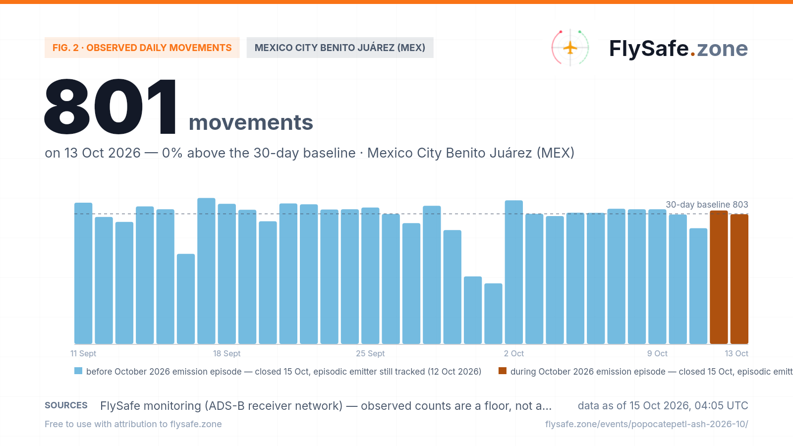
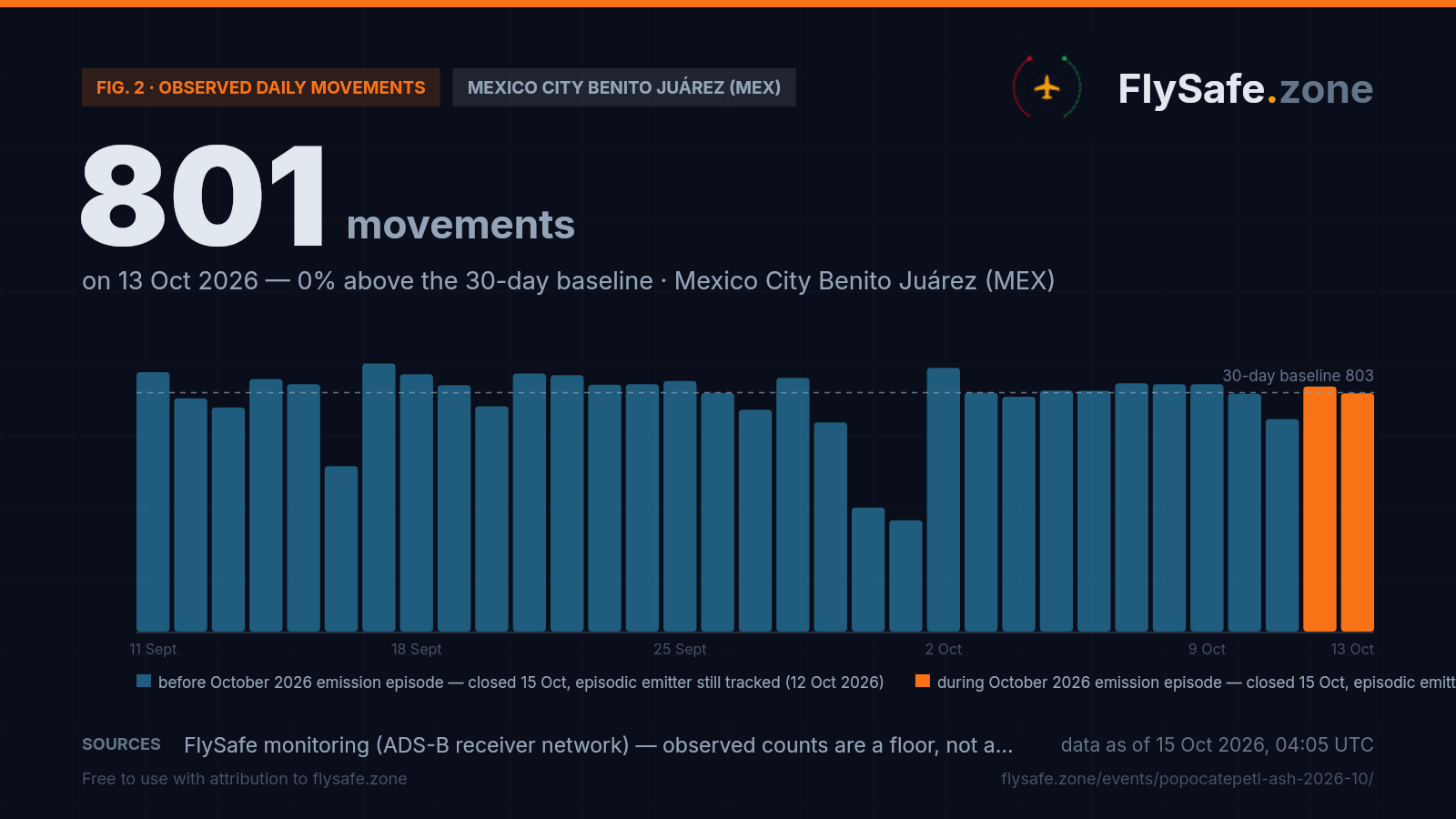
- Observed MEX traffic read 824 movements on 12 October and 801 on 13 October against an ~803 baseline — 12 October provisional, 13 October rated a normal day in our MEX brief. 14 October, the busiest day of the episode, has no usable reading yet: the first pass of the nightly ingest holds about a tenth of a normal day worldwide, and the bulk lands on 16 October.
Advisory timeline — how active is this episode
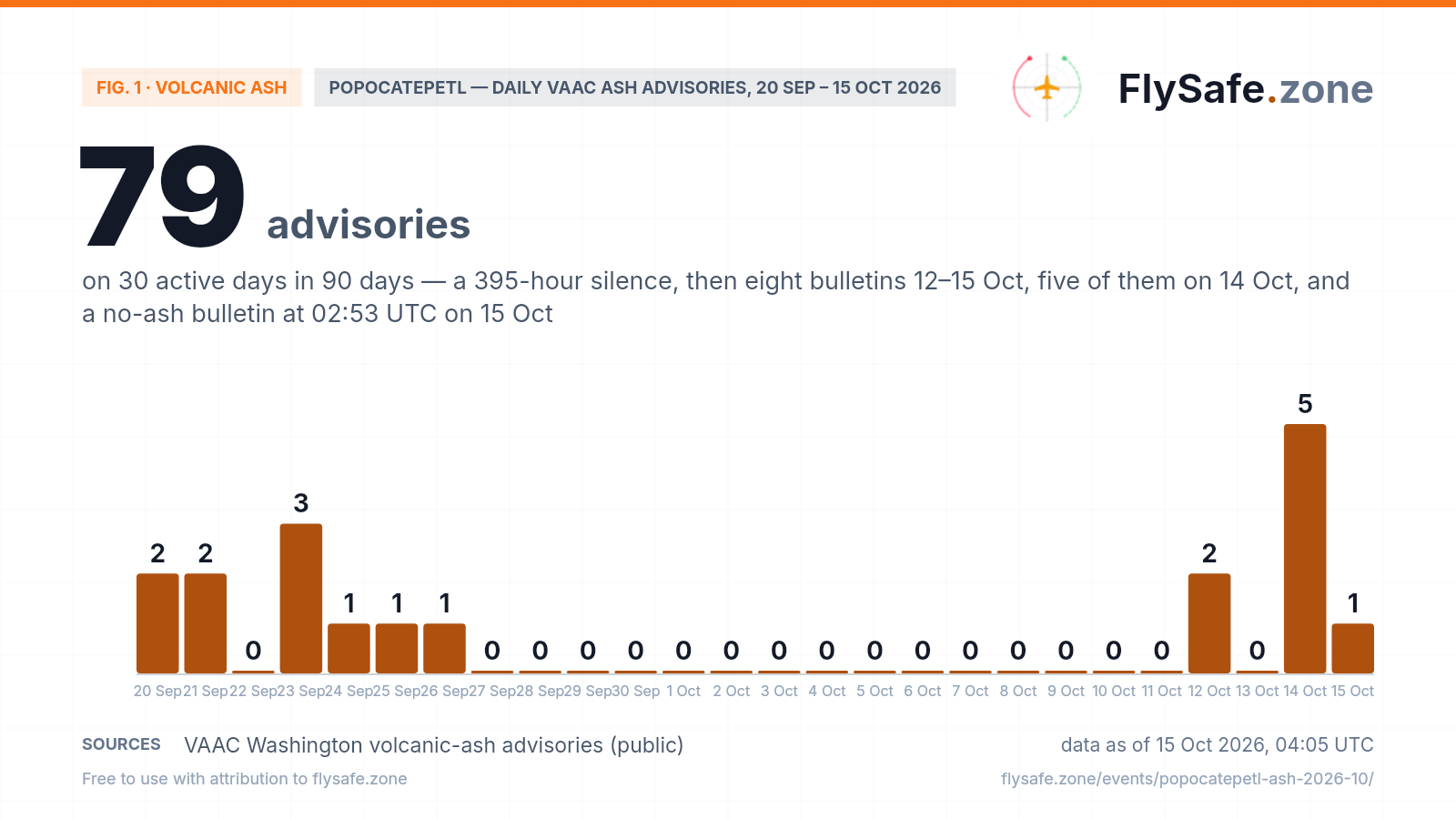
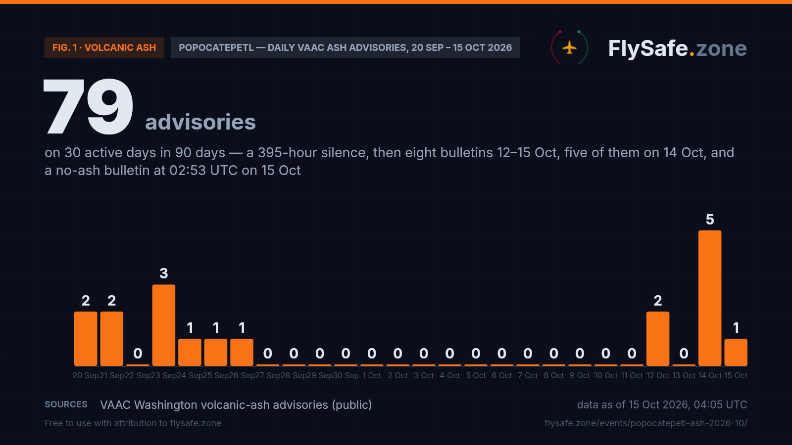
Popocatepetl is an episodic emitter: VAAC Washington has issued 79 ash advisories on 30 active days over the last 90 (since 21 July), and 181 on 64 days since 12 May, when our advisory collection begins — so every count here is a floor on the volcano's history, not its start. It works in bursts separated by silences. The September 2026 episode ran from 1 to 26 September (15 advisories on nine days, clusters on 20–25 September, a no-ash bulletin at 03:04 UTC on 26 September), and the silence that followed — 395 hours, to 14:09 UTC on 12 October — is the longest in our record, ahead of 348 hours in early September and 209 hours in June. The October episode this page opened on ran eight bulletins in 61 hours: advisory #350 at 14:09 UTC on 12 October (a discrete emission to FL200 moving 225° at 10 kt), a no-ash bulletin at 20:10 UTC the same day, nothing on 13 October, then five bulletins on 14 October — ash observed in satellite imagery about 22 NM from the summit at 02:31 UTC (FL220, moving 270° at 20 kt) and about 55 NM from the summit at 08:24 UTC (FL240, moving 315° at 20 kt), a dissipation bulletin at 14:24 UTC, a new webcam-observed emission to FL200 at 14:59 UTC, and a compact area of very recent emission at 20:54 UTC — and the closing bulletin at 02:53 UTC on 15 October, which reports no ash identifiable under partly cloudy conditions, expects none at the 6-, 12- and 18-hour forecast times and schedules no further advisory. The bars count every bulletin, including the three that reported no ash (12 October 20:10, 14 October 14:24 and 15 October 02:53 UTC); five of the eight carried a drawn ash area. The 13 October zero is the volcano's own quiet day, not a hole in the feed: VAAC centres issued 41 bulletins across 11 volcanoes on 13 October and 36 across 10 on 14 October, and the stream was live through the closing bulletin. The 90-day window has rolled since the 12 October version of this page, so its 78-on-30 count now reads 79 on 30; 15 October is a partial day. Daily advisory count, 20 September – 15 October:
Fig. 1 — Popocatepetl daily ash advisory count, VAAC Washington (Sep–Oct 2026) · * partial day · Data as of 15 Oct 2026, 04:05 UTC · Source: VAAC Washington volcanic-ash advisories (public).
Airports in the exposure zone
| Airport | Size | Distance from vent | FIR |
|---|---|---|---|
| Puebla Hermanos Serdán (PBC) | medium | 30 km · east-north-east of the vent — outside every observed and forecast ash area of the episode; the ash went west, nearest edge 28–30 km on every bulletin | MMFR |
| Mexico City Benito Juárez (MEX) | large | 66 km · north-west — inside none of the five observed or five forecast ash areas; nearest edge ~30 km observed and ~32 km forecast (08:24 UTC 14 Oct, FL240, moving 315°) | MMFR |
| Felipe Ángeles International (NLU) | large | 90 km · north-north-west, beyond MEX — outside every area; nearest edge ~65 km (08:24 UTC 14 Oct) | MMFR |
| Toluca Adolfo López Mateos (TLC) | medium | 105 km · west — the closest call of the episode: outside the 08:24 UTC 14 Oct observed area by ~7 km and its 6-hour forecast by ~10 km; 13 km from the 02:31 UTC forecast area; 32 km or more on every other area | MMFR |
Distance alone does not determine impact — wind direction and the flight levels the ash reaches decide which airports and routes are affected on a given day. FIR = Flight Information Region.
What our monitoring shows: Mexico City's traffic ran at baseline through the episode — 824 and 801 observed movements on 12–13 October; 14 October is not yet measurable
FlySafe tracks observed departures and arrivals at 493 airports from crowdsourced ADS-B receiver data. Observed counts are a floor, not a total — receiver coverage varies — but an airport measured against its own baseline is a reliable shape. Mexico City Benito Juárez's last 30 days:
Fig. 2 — Observed daily movements at MEX, 11 Sept – 13 Oct (latest complete UTC day). Data as of 15 Oct 2026, 04:05 UTC · Source: FlySafe monitoring (ADS-B receiver network).
- Baseline: ~803 observed movements/day at MEX — the 30-day yardstick this page set on 12 October and keeps. The week before the episode (5–11 October) averaged 804; the settled days from 17 September to 11 October ran 703–901, leaving aside 30 September and 1 October (see below).
- Through the episode: Monday 12 October 824 (+3%), Tuesday 13 October 801 (level with baseline). Advisory #350 was issued at 14:09 UTC on 12 October, so that day carries about ten hours of the episode; 13 October was the silent day between the two pulses. Mondays before it read 849, 867, 853 and 810; Tuesdays 831, 862, 703 and 809. Our MEX airport brief rates 13 October a normal day, 4% under its own Tuesday baseline of 831, with a 7-day average of 786.
- 14 October — the day that mattered — has no usable reading yet. Five bulletins, FL240, ash about 55 NM from the summit, drift turning north-west past Toluca: and the receiver network's first nightly pass (02:34 UTC on 15 October) holds about 15,000 flights worldwide against 128,000–143,000 on 10–13 October, and 157 movements for MEX. That is the feed's normal cadence — roughly a tenth of a day arrives on the first night, the bulk on the second — not a reading. We do not plot 14 October; the MEX airport brief carries the day once it settles.
- Bookkeeping. 12 October is plotted at 824, our recount from the raw flight records; the daily aggregate stores 693 because the trailing-days refresh at 03:25 UTC today cut the day short, and the figure stays provisional until it settles on 16 October. 13 October (801; aggregate and recount agree) settles on 17 October. Three corrections to the 12 October version of this page: 9 October, plotted then at 243 and flagged as a coverage gap, settled at 831; 11 September, plotted at 0 and called a partial-coverage reading, holds 872 in the aggregate — the zero was the edge of the 30-day window, not a reading; and the 11 October Sunday, which the page had not yet seen, settled at 714 — the lowest Sunday of the window (757, 746 and 789 before it), a day before the episode opened, and not attributed to anything by our data.
- Two low days that are not the volcano's. 30 September (417) and 1 October (374) now match the raw recount exactly, so they are settled values rather than collection gaps; departures fell to 175 and 155 while arrivals held at 242 and 219. Popocatepetl issued no advisory between 26 September and 12 October, so both days sit inside its silence; their cause is not established in our data. 16 September (556) is the day covered by our MEX traffic-drop brief.
- Honesty note — this is not an attribution. These are observed movements from a crowdsourced ADS-B receiver network: a floor, not the airport's official total, and recent days revise as data backfills. A movement count at MEX says the airport kept operating at its usual observed level while the ash areas stayed 30 km or more away; it says nothing about reroutes, holding or added track miles, which this feed cannot see.
FIR level: across the Mexico FIR (MMFR), observed en-route traffic ran 1.00× expected on 12 October, 1.04× on 13 October and 1.03× on 14 October (48 readings a day), after 0.89× on Sunday 11 October — a FIR-wide band we report and do not attribute. Our detection layer opened no airspace-disruption entry for MMFR at any point since 1 October. Live view: MEX airport brief · live ash map.
What it means for flights
FL200 matters for the Mexico City approach corridor. Written 12 October: Ash to FL200 (~20,000 ft) sits below most long-haul cruise levels (FL310–FL390 over central Mexico) but inside the working altitudes for CDMX-area arrivals, departures and regional turboprop routes. An active VAAC advisory at this level is a planning obligation — dispatchers file around the advisory polygon on every flight plan through MMFR. The practical effect is added track miles and fuel on affected routes, not a shutdown.
Why MEX is outside the ash cloud — wind geometry. Written 12 October: Popocatepetl sits at 19.02°N 98.62°W; MEX is 19.44°N 99.07°W — NNW of the vent. Advisory #350 shows ash moving WSW at 10 kt: the observed polygon is a compact area within ~25 km of the summit, and the T+6 forecast extends WSW to ~99.3°W but at latitudes 18.75–19.03°N, well south of MEX (19.44°N). WSW drift is carrying ash away from Mexico City. The T+12 forecast already calls no ash expected — meaning the current burst is tracking to clear within the advisory window. That is a measured fact about this advisory; wind direction is forecast-dependent and can shift.
Popocatepetl's episodic pattern — not a persistent emitter. Written 12 October: Unlike persistent emitters that issue advisories daily without interruption, Popocatepetl runs in discrete bursts. In 90 days (since 14 July), it was active on 30 of 90 days — roughly one day in three. The September episode had sporadic clusters from 1 September through 25 September (15 advisories total), cleared on 26 September, then 16 consecutive quiet days before today. Each episode typically lasts days, not weeks; the detection layer checks cadence, FL top and ash proximity to MEX every three hours and re-opens this page if escalation fires.
Puebla (PBC) at 30 km — the closest exposure indicator. Written 12 October: Hermanos Serdán International is the nearest significant airport to the vent at 30 km, within the advisory polygon perimeter for higher-intensity bursts. Scheduled domestic service at PBC is limited, but polygon-contact at PBC in prior September episodes preceded advisory expansions; it serves as the early-warning airport. This episode's polygon remains east of PBC as of advisory #350.
Three signals we watch for escalation. Written 12 October: The picture changes if: (1) daily advisory count climbs to 4–5+ per day (current: 1, episode in progress); (2) reported ash tops rise significantly above FL200 — pushing into the cruise band; or (3) the ash polygon reaches the MEX area (~19.3–19.5°N, 99.0–99.2°W). None of these has triggered on advisory #350. Automated multi-signal analysis updates this page and the MEX airport brief on each three-hour cycle.
What the data showed — October episode closed 15 Oct. We close this page on the signals it opened on — the advisory stream and the question of whether the drawn ash areas reached Mexico City — and we answer the three escalation tests it set on 12 October. The sequence. Between 14:09 UTC on 12 October and 02:53 UTC on 15 October VAAC Washington issued eight Popocatepetl bulletins on three days; five carried a drawn ash area and three reported no ash. The opening advisory (#350) described a discrete emission to FL200 moving 225° at 10 kt, its observed area within about 24 km of the summit; six hours later the 20:10 UTC bulletin reported no ash detected, with weather cloud over part of the summit, and 13 October passed without a bulletin. The second pulse was the one that mattered. At 02:31 UTC on 14 October (#352) ash was observed in satellite imagery about 22 NM from the summit, GND/FL220, moving 270° at 20 kt, with model guidance for west-north-west drift and the summit itself hidden by cloud; at 08:24 UTC (#353) the observed area reached about 55 NM from the summit at GND/FL240, moving 315° at 20 kt — its far edge about 100 km from the vent, the episode's highest top and widest area, laid out west of the summit between 18.98° and 19.28°N — south of the capital (19.44°N) and out to Toluca's longitude — with model guidance for west to west-south-west movement through the next six hours. The 14:24 UTC bulletin (#354) reported the ash dissipated and no new emission under clear skies; 35 minutes later #355 reported a new emission observed on the webcam to about FL200 around 14:40 UTC, moving 270° at 10 kt; at 20:54 UTC #356 drew a compact area of very recent emission within about 5 km of the summit, GND/FL200, moving 270° at 5 kt, with model winds backing toward the east-north-east. The 02:53 UTC bulletin on 15 October (#357) reports no ash identifiable under partly cloudy conditions, no recent reports of ash received, none expected at the 6-, 12- and 18-hour forecast times and no further advisory scheduled. The three tests. Cadence: the page asked for 4–5+ bulletins a day — 14 October produced five, four of them with a drawn area, so the test fired. Height: the page asked whether tops would rise well above FL200 — FL220 at 02:31 UTC and FL240 at 08:24 UTC on 14 October did, before the afternoon and evening emissions fell back to FL200; the test fired. Reach: the page asked whether an ash area would reach the MEX box (~19.3–19.5°N, 99.0–99.2°W) — none did. Testing the published airport coordinates against every polygon in the eight bulletins, Mexico City Benito Juárez (MEX) fell inside none of the five observed or five forecast areas; the nearest edges were about 30 km (observed) and 32 km (6-hour forecast), both on the 08:24 UTC advisory. The geometry did not follow the 12 October text, which read the first advisory's south-westerly drift as carrying ash away from the capital and named Puebla as the early-warning airport. On 14 October the motion swung to west and then north-west, the ash lay south of the capital with its area reaching Toluca's longitude, and the airport it came closest to was Toluca (TLC): about 7 km outside the 08:24 UTC observed area and 10 km outside its forecast, 13 km outside the 02:31 UTC forecast area, 32 km or more on every other area. Puebla (PBC), 30 km east-north-east of the vent, stayed 28–30 km from every area; Felipe Ángeles (NLU) 65 km or more. FIR level. Across the Mexico FIR (MMFR) observed en-route traffic ran 1.00× expected on 12 October, 1.04× on 13 October and 1.03× on 14 October (48 readings a day), after 1.10× on 8–9 October and 0.89× on Sunday 11 October — no FIR-wide dip on the days the ash was airborne, a band we report and do not attribute. Our detection layer opened no airspace-disruption entry for MMFR at any point since 1 October, and no volcanic-ash SIGMET for Mexican airspace appears in our SIGMET record for 12–15 October (that record holds 13 Popocatepetl SIGMETs since 14 July, the last on 25 September; it is our collection, not an official archive). Recovery number: Mexico City observed 824 movements on Monday 12 October and 801 on Tuesday 13 October against the page's ~803 baseline — 3% above it and level with it, inside the 703–901 range of the settled days from 17 September to 11 October (30 September and 1 October aside), and level with the 804 a day of the week before the episode (5–11 October). Mondays before it read 849, 867, 853 and 810; Tuesdays 831, 862, 703 and 809. The MEX airport brief rates 13 October a normal day, 4% under its Tuesday baseline of 831. Toluca itself is a small field in our network — 32–40 observed movements a day on 6–9 October, 30 on 13 October — a floor that cannot say whether any flight there was moved or held. Four honesty notes. First, 14 October, the busiest day of the episode, has no usable traffic reading yet: the receiver network's first nightly pass (02:34 UTC on 15 October) holds about 15,000 flights worldwide against 128,000–143,000 on 10–13 October and 157 movements for MEX — the feed's normal first-night fraction, not a reading; the bulk lands on 16 October, so the one day on which ash at FL240 passed 30 km from the airport cannot be scored by us today. Second, 12 October is plotted from a recount (824) because the aggregate stores a clipped 693, and it stays provisional until 16 October; 13 October settles on 17 October. Third, the closing bulletin was written under partly cloudy skies; its forecast covers 18 hours and its remark reports no recent reports of ash, not that emission has ended. It is the 44th bulletin of this shape in our record since 12 May, and each of the 43 before it was followed by a new advisory with an ash area — after a median of about 30 hours, 18 of them within a day, twice within this episode (30 hours after the 12 October no-ash bulletin, 35 minutes after the 14 October one), and once after 395 hours. So this closes the October episode as the advisory stream defines it, not Popocatepetl's activity; the 12 October text above is kept as written, with the 90-day record now standing at 79 advisories on 30 days and the airport bearing corrected from NNW to north-west. Fourth, the traffic figures are a floor from a crowdsourced ADS-B receiver network, and nothing in them ties any movement at MEX or Toluca to the volcano: dispatchers file around published ash areas, and that cost — track miles, fuel, holding — does not show in a movement count. Automated multi-signal analysis keeps Popocatepetl under continuous watch, and a new brief opens from the same cycle if VAAC Washington resumes advisories with an ash area.
Passenger questions, answered from the data
As of 04:05 UTC on 15 October 2026, no Popocatepetl ash advisory is in force: VAAC Washington's 02:53 UTC bulletin reports no ash identifiable, expects none over the next 18 hours and schedules no further advisory. Through the eight bulletins of 12–15 October, Mexico City Benito Juárez (MEX), 66 km north-west of the vent, fell inside none of the five observed or five forecast ash areas; the nearest edge passed about 30 km from the airport at 08:24 UTC on 14 October. Popocatepetl's no-ash bulletins have always been followed by new advisories, so check your airline's status on the day of travel and the live ash map.
Reported tops were GND/FL200 (~20,000 ft / ~6,100 m) on the 12 October advisory and on the afternoon and evening bulletins of 14 October, GND/FL220 at 02:31 UTC and GND/FL240 (~24,000 ft / ~7,300 m) at 08:24 UTC on 14 October, when ash was observed about 55 NM from the summit. All of it sits below typical long-haul cruise altitude and inside the band used by arrivals, departures and lower-level routes across the Mexico FIR (MMFR).
In the 90 days to 15 October 2026, VAAC Washington issued 79 advisories on 30 active days — bursts of one to five bulletins a day separated by silences. The September 2026 episode ran 1–26 September (15 advisories on nine days); the 395-hour silence that followed, to 12 October, is the longest in our record since 12 May; the October episode produced eight bulletins in 61 hours, five of them on 14 October alone. Since 12 May: 181 advisories on 64 days, 44 of them no-ash bulletins, each of the earlier 43 followed by a new ash advisory after a median of about 30 hours.
Because the page tracks one episode with measurable signals: the emission that opened at 14:09 UTC on 12 October, its cadence and reported tops, and whether the drawn ash areas reached Mexico City. The second pulse of 14 October fired two of the page's three escalation tests (five bulletins in a day; tops to FL240) and not the third (no area reached MEX; the closest call was Toluca at about 7 km), and the 02:53 UTC bulletin on 15 October reports no ash identifiable and schedules no further advisory. The volcano has not stopped in any permanent sense — its no-ash bulletins have always been followed by new advisories — so a fresh brief opens from the same monitoring cycle if VAAC Washington resumes advisories with an ash area, and the live ash map keeps updating in the meantime.
Aircraft do not fly through reported ash — dispatchers route around advisory polygons, and regulators close airspace if ash reaches it. We publish the measured picture (advisory cadence, reported flight levels, directions of motion, the geometry of each ash area against each airport, observed airport movements and FIR-level en-route counts); routing and go/no-go decisions belong to operators and the relevant authorities.
For media — the full kit
Everything on this page — charts, CSV, quotes — is published under CC BY 4.0: free to reuse with attribution to FlySafe.zone. Charts come in dark (social/web) and light (print/light layouts) versions; attribution and license are embedded in every file.
“Mexico's Popocatepetl volcano resumed ash emission at 14:09 UTC on 12 October 2026 after a 395-hour silence, the longest in the record kept since 12 May, and produced eight VAAC Washington bulletins in 61 hours — five of them on 14 October, when ash was observed about 55 NM from the summit at FL240 and moving north-west, passing about 30 km from Mexico City Benito Juárez airport and about 7 km from Toluca; neither airport fell inside any of the five observed or five forecast ash areas, the 02:53 UTC bulletin on 15 October reported no ash identifiable with no further advisory scheduled, and Mexico City's observed traffic read 824 and 801 movements on 12–13 October against an ~803 baseline, according to flight-monitoring service FlySafe.zone.”
Boilerplate — about the source (for your article footer)
FlySafe.zone monitors airspace risk and observed airport activity worldwide: 334 flight-information regions scored daily, GPS-interference signals, volcanic-ash exposure and daily observed movements at 493 airports from the crowdsourced ADS-B receiver network. Methodology: flysafe.zone/methodology.
Need a different cut of the data, a comment, or numbers for another airport? Leave an email — we answer fast during active events.